
Hovering beyond the horizon
Minnkota's research partnerships are harnessing both academic and commercial UAS expertise to find more efficient ways to inspect power lines.
On a bright winter day in rural Nelson County, N.D., two bundled-up men stood in a snowy field with a large, propeller-adorned contraption hoisted between them.
Synchronized, they spun in circles. They swayed one way, then the other way. The equipment between them followed their lead.
It looked…bizarre.
“We call this the preflight dance of the UAS,” Paul Snyder laughed, watching the distinctive calibration routine from the safety zone yards away. Snyder, the director of the University of North Dakota’s UAS (unmanned aerial systems) program, joined the Northern Plains UAS Test Site (NPUASTS) and other UND representatives for an afternoon of flight along Minnkota’s power lines just east of Stump Lake.
.jpg)
The goal of the mission – to complete a safety case that would pave the way for Minnkota to use drones beyond visual line of sight (BVLOS) for monitoring its lines autonomously. NPUASTS Director of Operations Jakee Stoltz said applying for the necessary waiver requires data, operational history and written procedures.
“We joke that the submission is heavier than the drone sometimes,” Stoltz quipped. “These flights will help us prepare that documentation to submit a nice strong safety case to the FAA.”
“Today we’re identifying how far out we can fly and still maintain the orientation of the ‘bird’ – or which direction the UAS is going while we can visually see it – and identify where that location is,” Snyder explained. “If we can get to a point where we can take it outside of visual line of sight to inspect lines, there‘s a lot we could do – everything from detecting flaws to downed wires to vegetation encroachment.”
This research partnership between Minnkota, UND and NPUASTS – made possible by a Research ND grant from the ND Department of Commerce and additional funding from Border States – is just one UAS project that Minnkota hopes will help make the maintenance of its power delivery systems safer, more efficient and, ultimately, more cost-effective.
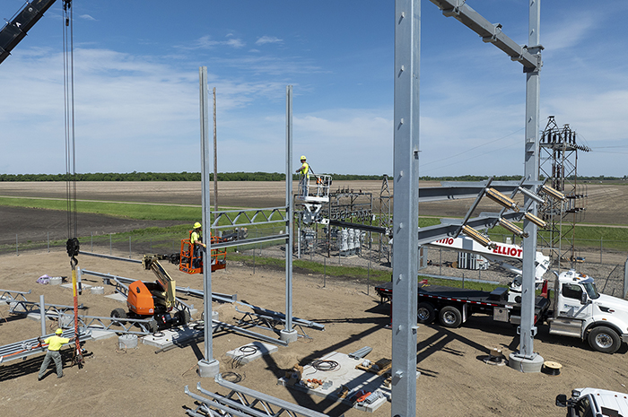
Minnkota’s UAS alliance with UND goes back about three years, when the cooperative was constructing its 345-kV transmission line from Center to Grand Forks, N.D. At that time, UND helped Minnkota fly over the lines to identify potential issues from the air.
The research goals have evolved since then.
“UND, as a research university, tries to find some new way to look at things and provide value to us, the end user and partner,” said Wayne Lembke, Minnkota engineering manager. “The scope changed to beyond visual line of sight. That’s one thing we haven’t done much in our industry.”
.jpg)
University to utility
In addition to its academic connection, Minnkota is teaming up in the private sector for more industry-leading UAS research.
Minnkota is working with the drone services company SkySkopes, eSmart Systems, Border States and Microsoft on a first-in-the-region pilot project to digitally document and archive thousands of drone-captured images of power lines and their components. A utility could then review and analyze that data, helping to automate the drone inspection process when a line issue arises.
.jpg)
For a week in late December, SkySkopes drone pilots flew eSmart technology along 45 miles of 69-kV line from Page, N.D., east across Interstate 29, and then south to Harwood, N.D., taking photos of the pole tops from every angle. Minnkota could use those images immediately to check for loose bolts, conductor damage or cracked components. However, eSmart’s pilot project system scans the line repeatedly, so that the software can learn to detect differences from flight to flight, easily pointing out potential issue areas.
Terry Sando, eSmart Systems business manager for UAS operations (and mayor of Hillsboro, N.D.), said that eSmart initially conceived and tested this system in its headquarters country of Norway. The team was searching for a way to bring the technology to the Upper Midwest.
“We were working with our strategic partner for UAS operations, SkySkopes, and Minnkota was right at the back door,” Sando said.
“Only in North Dakota are you going to find such world-class subject matter experts and use cases like what Minnkota put forth,” added SkySkopes president and CEO Matt Dunlevy. “I think that the team that we put together on this is one that’s difficult to find.”

The eSmart Connected Drone system photographs and scans more than 180,000 images an hour of components along a power line – more than three times what can be done manually in a year. The collective team has also used drones to gather 16 miles of LiDAR data from a 115-kV line near Thief River Falls, Minn. LiDAR is a surveying system that uses reflected light imaging to create a 3-D point cloud model of a land area. It's a promising technology for quickly capturing detailed data on hundreds of miles of lines and their corridors.
“LiDAR, right now, is the one of the best reasons to be flying unmanned aircraft,” Dunlevy said.

Beyond finding innovative ways to inspect lines faster and more effectively, these research efforts could bear an even more valuable benefit for Minnkota – the enhanced safety of its crews. Unmanned inspections and surveys mean line workers don’t need to climb poles, plane and helicopter pilots can avoid challenging areas and crews can remain in safe zones during storm damage assessments.
Power of partners
Minnkota is also planning for a drone of its own, with an aim of training and licensing personnel for UAS flights and investing in an entry-level drone for small inspections and other utility uses.
“I see Minnkota using UAS more and more, as long as it can get more efficient and the cost can go down on LiDAR and other general inspections,” said Power Delivery engineer Brenden LaHaise, part of the team digging deeper into drone possibilities for Minnkota. “We’re getting in front of this technology, and it will be interesting to see where it goes.”
Perfectly paired partnerships will be integral to reaching new heights with UAS. Minnkota knows this and has already assembled a dynamic, collaborative team.
“We can go to SkySkopes, and they know exactly what we want, and we know what kind of product they have,” LaHaise said. “We can work with other utilities, too, and learn from their experiences and get ideas from them.”
“You see this so much – academia and industry working together,” Snyder emphasized as a UND drone buzzed along the lines behind him. “We’re trying to solve industry problems, seeing ways we can increase efficiencies for companies so that they can move forward and do bigger and greater things.”
...
5301 32nd Avenue South
Grand Forks, ND 58201
P: 701-795-4000
